

← All historic cities of Uzbekistan
Uzbekistan • City chronicles
The History of Karshi
Karshi, also written Qarshi, is the principal city of the Kashkadarya Region. Its history belongs to an oasis where successive urban centres developed under different names and rulers. Ancient Nakhshab, Islamic Nasaf and later Karshi are connected chapters, but they should not be imagined as an unchanged town standing within one fixed boundary.
The surviving mosques, bridge and educational buildings reveal only part of this long story. Archaeological sites around the modern city provide the earlier chapters, while its streets reflect later political and economic change.
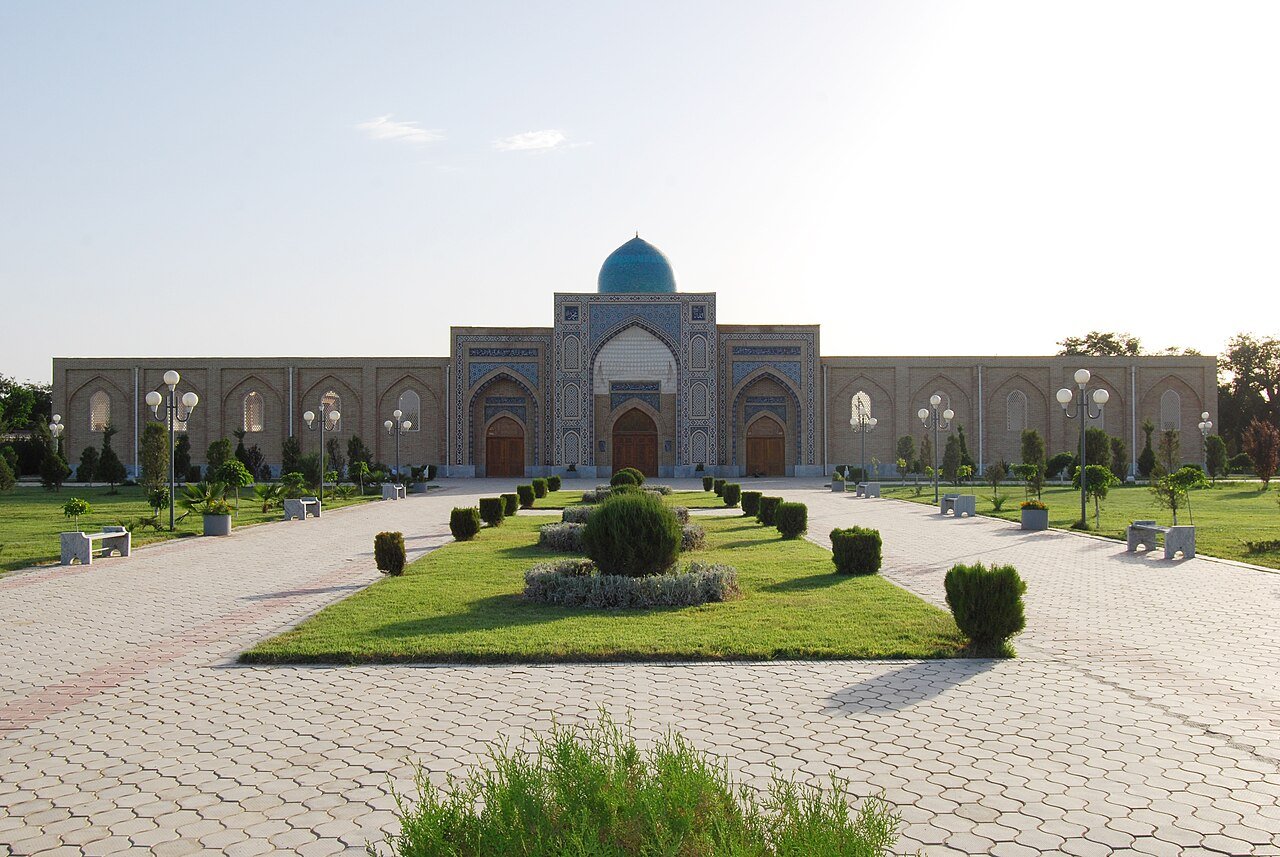
At a glance: Karshi through time
- Antiquity: fortified settlements develop in the southern Sogdian oasis.
- Early Islamic period: Nasaf becomes a recognised centre of urban life and scholarship.
- Early fourteenth century: the Chaghatay ruler Kebek builds a palace near Nakhshab; the name Karshi is associated with this new centre.
- Sixteenth century: major construction develops under the Shaybanids.
- Later centuries: the city remains important within the Bukhara state.
- Twentieth century: Soviet administration, irrigation and industry transform the region.
- Since 1991: Karshi develops as a regional centre of independent Uzbekistan.
An oasis with more than one urban centre
Karshi's early history belongs to the lower Kashkadarya oasis, a landscape in which settlements shifted and developed over a long period. The ancient and medieval names Nakhshab and Nasaf connect the modern city with that history, but the connection is not a claim that every period occupied exactly the same streets. Political patronage, water distribution and the fortunes of particular settlements changed the location and emphasis of urban life.
The oasis formed part of southern Sogdiana and connected routes between the Zarafshan centres and lands farther south. Its importance rested on agriculture and local exchange as well as travellers passing through. A town on a route still required food, water, materials and labour. Those practical foundations explain why the surrounding cultivated landscape belongs in a history of Karshi, rather than appearing only as the scenery beyond its monuments.
The city's 2,700-year anniversary in 2006 commemorated this deep urban past. Such an anniversary is best understood in relation to the archaeology and history of the oasis. It does not establish that each modern district was founded in a single precisely documented year. Distinguishing commemorative chronology from the evidence for individual sites makes the long history more credible and more interesting.
Yer Kurgan and the archaeological landscape
Yer Kurgan, also written Erkurgan or Yerkurgan, is a major archaeological site near Karshi. Its name evokes an earthen fortress, and its remains reveal an earlier urban world of defences, buildings and organised space. It should be treated as a distinct site with its own phases, not merely as a picturesque ruin attached to a general claim that Karshi is ancient.
Archaeology requires a different way of looking from a visit to a restored mosque. A wall line, platform or excavation trench may be the most informative feature, even when it lacks a dramatic façade. Plans and interpretation help distinguish administrative, residential and religious areas. The material can reveal how a settlement functioned and how its occupation changed, rather than supplying only a list of famous names.
The archaeological record also includes ordinary objects. Pottery, tools and fragments of decoration can help date layers and identify activities. Their value is not limited to artistic beauty. A modest vessel found in a documented context may tell more about daily life than an impressive object without a clear origin. A museum visit or guided explanation can make these connections visible before or after an excursion to the site.
Sogdiana, exchange and the limits of legend
The Nakhshab oasis participated in the wider Sogdian world, whose communities combined agriculture, urban production and extensive commercial connections. This background places the region within Central Asian history before the Islamic centuries. It also explains why a local settlement could be connected with larger political events without every event occurring within the boundaries of the present city.
Stories about Alexander the Great and the Sogdian resistance are frequently attached to places across the region. They can preserve an important sense of historical identity, but specific claims about a commander's birthplace or a particular visit require evidence. A broad connection to the campaigns in Sogdiana does not establish every local anecdote. Where documentation is uncertain, it is better to identify a tradition as a tradition.
The same care applies to the phrase Silk Road. The oasis belonged to networks of movement, but those networks included short journeys and regional trade as well as long-distance exchange. Farmers bringing produce to market and artisans supplying local customers helped sustain the system. Karshi's history becomes more substantial when these activities are included alongside the more familiar image of caravans travelling between great cities.
Nasaf in the Islamic world
Nasaf is the name often encountered in Arabic and Islamic historical writing. Its appearance in the geographical designation al-Nasafi connects the city with scholars whose influence extended far beyond the oasis. Intellectual history can therefore preserve a city's reputation even when the buildings in which people studied no longer survive. Books and teaching networks carry a different kind of evidence from walls and roads.
The spread of Islamic institutions was a process involving communities, patrons and successive generations of teachers. A city needed more than a mosque to become a centre of learning. Students required support, texts had to circulate and scholarly authority depended on relationships with other centres. Nasaf belonged to that wider world of movement and exchange rather than functioning as an isolated school with a single unchanging tradition.
The names Nakhshab and Nasaf should not be treated simply as two successive labels on the same street sign. Language, textual convention and shifting settlement geography all contribute to their use. A source may describe an oasis or district as well as a town. Reading the context carefully avoids assigning a statement about the broader region to a particular surviving building in modern Karshi.
Scholars named al-Nasafi
Several important scholars bore the designation al-Nasafi, and they should not be merged into one biography. Abu al-Muin al-Nasafi is associated with the development of Maturidi theology, while Aziz al-Din Nasafi was a thirteenth-century mystical writer whose Persian works circulated widely. Shared geographical association does not mean that they lived in the same century, wrote in the same genre or belonged to one immediate family.
This distinction is useful when visiting memorials or reading abbreviated labels. A monument may commemorate a scholar's legacy through modern architecture, while the person's actual career involved several places. Birth, study, teaching and burial can have different locations. The history of a memorial and the history of the individual it honours are connected but separate subjects.
The intellectual legacy also gives visitors a reason to look beyond architecture. A text can carry the name of Nasaf into distant scholarly and religious environments. Its influence depends on copying, reading, commentary and teaching, activities that may leave few visible traces in the original city. Karshi's historical importance therefore cannot be measured only by the number or height of its surviving monuments.
The Mongol period and Kebek's residence
The Mongol conquest transformed the political order of Central Asia, and the oasis later formed part of the Chaghatay realm. In the early fourteenth century, the ruler Kebek established a palace near Nakhshab. Historical scholarship connects the development of Karshi and its name with that residence. The episode belongs to a period when rulers of Mongol descent were deeply engaged with the administration and resources of settled territories.
This chronology corrects a common confusion in simplified travel accounts. The palace associated with the city's name should not be attributed to Timur as a young child in the 1340s. Kebek's residence represents an earlier and separate political chapter. A famous ruler's name can become attached to many places in popular memory, but a city history should preserve the distinctions between patrons and periods.
A palace could change the balance of an oasis by attracting officials, suppliers, soldiers and craftsmen. The resulting settlement growth was not only the construction of an elite residence. It involved a surrounding economy of service and administration. Karshi's development illustrates how political decisions could create a new urban focus while older centres retained different functions or declined.
From Timurid territory to Shaybanid patronage
Karshi's later medieval history unfolded within the political changes that affected Transoxiana as a whole. Timurid rule and the subsequent rise of the Shaybanids altered patronage and authority, while the city continued to depend on its regional position and agricultural surroundings. The surviving monumental landscape is particularly informative for the sixteenth century, when major religious and infrastructural projects contributed to its identity.
The comparison with Shakhrisabz is helpful. Both cities belong to Kashkadarya, but their best-known monuments express different concentrations of patronage. Shakhrisabz is strongly associated with Timur and his family; Karshi's bridge and Kok Gumbaz help explain a later phase of urban investment. Similar architectural vocabulary should not obscure this chronological difference.
Patronage also operated through different types of building. A mosque supported worship and public gathering, a madrasa organised teaching, and a bridge facilitated movement. Together they served the city more broadly than a royal residence alone. Their survival provides an opportunity to understand government through practical and social institutions as well as through symbols of prestige.
Kok Gumbaz: a mosque of the late sixteenth century
Karshi's Kok Gumbaz Mosque belongs to the late sixteenth century and is associated with the patronage of Abdullah Khan II. The regional heritage account identifies an inscription dating its completion to 999 AH, corresponding to 1590–1591. This more precise evidence is valuable because the name Kok Gumbaz, meaning blue dome, occurs at other sites, including Shakhrisabz. They are different buildings with different histories.
The mosque's scale and form should be understood in relation to collective worship. A substantial prayer space organised people through orientation, enclosure and circulation. The dome contributed to the building's external identity, but the institution's purpose lay in use. Looking at entrances, transitions and the relationship between enclosed space and its surroundings helps recover that practical dimension.
Restoration adds another layer to the present appearance. Colour and decorative surfaces may have been renewed, while structural fabric preserves older work. A visitor should therefore distinguish the date of the foundation from the age of every visible tile or plaster surface. The mosque's importance lies in both its historical origin and the continuing process through which it has been maintained and presented.
The Kashkadarya bridge and the history of movement
The historic bridge over the Kashkadarya is commonly dated to 1583 and associated with Abdullah Khan II. It is also known by several later or popular names. A name honouring Timur does not by itself change the construction date or patronage of the surviving structure. This is a useful example of why documentary chronology should be kept separate from commemorative naming.
A bridge reveals the practical demands of an urban route. It allows people, animals and goods to cross a watercourse more predictably, linking approaches to markets and the city beyond. Its usefulness depends on the river, adjoining roads and continuing maintenance. The arches are therefore not merely an attractive pattern; they are part of an engineering response to movement and water.
Standing near the bridge, consider the scale of the crossing and its relationship to the surrounding landscape. A route's importance can survive changes in transport technology and urban growth, while the structure itself may require repair or adaptation. The bridge's long life connects several periods through repeated use, making it one of Karshi's clearest examples of infrastructure as heritage.
Odina and the changing uses of religious buildings
The Odina complex belongs to Karshi's historic religious landscape and is associated in local accounts with the area of Kebek's former palace. Its history includes changes in use and later interpretation. Descriptions sometimes attach sweeping claims to the institution, but those claims should be checked against specific evidence rather than repeated because they appear in an attractive travel summary.
The most informative architectural questions concern the organisation of worship and the relationship between supporting columns, arches and roofed spaces. A large building must manage circulation and load as well as visual effect. These practical choices help explain its plan. They also show why repair can alter the experience of an interior even when the general outline of the building remains recognisable.
Modern museum or memorial functions represent another stage in the site's life. They can preserve a building while changing the way visitors move through it and understand its past. A present display should therefore be distinguished from the structure's original religious use. The building becomes a record of successive institutions, each leaving traces in its fabric and public meaning.
Madrasas, baths and water storage
Karshi's heritage includes educational buildings associated with patrons such as Kulichboy and Khoja Abdulaziz, as well as baths and water-storage structures. These sites broaden the story beyond the most prominent mosque and bridge. They reveal a working city that needed places to study, wash, gather and manage essential resources. Their functions were connected to ordinary life as well as patronal reputation.
A madrasa's repeated rooms and courtyard arrangement reflect the needs of an institution, while a bath requires a different organisation of heat, water and movement. A sardoba, or covered reservoir, responds to the need to store water and protect it from the surrounding environment. Comparing these building types makes urban history tangible: each solves a different problem, and the city depended on the combination.
Smaller monuments may have complicated histories of repair or altered use. Their current appearance should not be assigned automatically to one patron or date. Local documentation and on-site interpretation are particularly useful for distinguishing original work from later additions. A modest building can provide valuable evidence when its history is explained accurately, without requiring claims that it is unique in all of Central Asia.
Karshi within the Bukhara state
For later centuries, Karshi's political history was closely connected with the state centred on Bukhara. It remained an important regional town with markets, administration, religious institutions and productive surroundings. The relationship to the capital did not erase local identity. Provincial centres had their own patrons and communities, and the practical business of government depended on them.
The nineteenth-century expansion of Russian power altered this framework, particularly after Bukhara came under Russian predominance. Karshi experienced the consequences through the wider political and commercial system rather than simply becoming identical to a directly administered Russian colonial city. The distinction between the Bukhara emirate and territories annexed outright matters when comparing Karshi with Tashkent or Fergana.
Markets and crafts continued between the major events usually highlighted in dynastic timelines. People repaired buildings, maintained water systems and organised household work. This longer continuity is part of what the surviving urban fabric represents. A city did not cease to have a history during decades without a famous battle or a new monumental foundation.
Soviet transformation of the Kashkadarya landscape
Soviet rule reorganised administration, agriculture and industry across Kashkadarya. Large-scale irrigation and development altered the relationship between the oasis, surrounding steppe and regional urban centres. Karshi expanded through new residential and administrative districts, becoming much larger than the historic core represented by its surviving monuments. The modern cityscape is the result of these changes as well as its earlier history.
Water remained central, but the scale and institutions of its management changed. Infrastructure could support new cultivation and population while creating continuing demands for maintenance and resources. Comparing older water-storage structures with the modern regional landscape reveals both continuity of need and a transformation in technology and organisation. The problem of sustaining settlement in a dry environment remained fundamental.
Religious buildings also encountered new policies and uses. Some survived through adaptation, while others lost the institutions that had supported them. Conservation and museum interpretation later selected particular structures for preservation. Their present condition therefore reflects twentieth-century decisions as well as the skill of the original builders. A complete reading of the city includes both layers.
Karshi today: reading a city across several sites
Since independence in 1991, restoration and heritage presentation have brought renewed attention to Karshi's monuments. The city continues to function as a regional centre, with contemporary buildings and infrastructure surrounding its older sites. The past is encountered in separate places rather than within one completely preserved historic enclosure. That arrangement requires a little context but also reveals how the city has continued to change.
A useful historical route combines different kinds of evidence. Kok Gumbaz introduces religious patronage; the bridge explains movement and engineering; a madrasa or bath reveals another urban institution. A museum or excursion to Yer Kurgan adds the earlier oasis. The aim is to connect the layers without pretending that they all belong to the same site or century.
Karshi's distinctive story is the movement of urban importance through an oasis: ancient settlement, the scholarly world of Nasaf, Kebek's residence, Shaybanid construction and modern regional development. Its value lies in those connections. With the chronology clear, a bridge, a manuscript name and an archaeological wall become parts of one substantial history rather than isolated attractions.
Reading the history on a visit
Combine Kok Gumbaz with the historic bridge, then use a museum or guided archaeological excursion to explore the earlier oasis. Keep the ancient sites, medieval centres and modern city distinct on your map.
Karshi pairs naturally with Shakhrisabz: the two cities show different forms of political patronage within the same broader region. One should not be treated merely as a stop on the way to the other.
Sources and further reading
- Encyclopaedia of Islam: Karshi — the palace of Kebek
- UNESCO, History of Civilizations of Central Asia, volume IV
- Uzbekistan Tourism: Karshi and its surviving monuments
Where simplified travel accounts conflict over the origin of the city’s name, this chronology follows the scholarly association with Kebek’s fourteenth-century residence.