

← All historic cities of Uzbekistan
Uzbekistan • City chronicles
The History of Namangan
Namangan’s history grows from the northern Fergana Valley: water channels, productive land, displaced communities and the work of artisans. Its monuments are less monumental than the great ensembles of Samarkand, but they preserve a distinctive story of religious patronage, neighbourhood life and urban growth.
The modern city should be distinguished from nearby Aksikent, one of the valley’s major archaeological sites. Their histories became connected through migration and regional change, but they were separate settlements.
At a glance: Namangan through time
- Early settlement: communities develop in the northern valley’s agricultural landscape.
- Seventeenth century: Namangan grows in importance; local histories connect its expansion with migration after the destruction of Aksikent by an earthquake.
- Eighteenth–nineteenth centuries: the city develops within the Kokand Khanate.
- 1821: the Yangiaryk canal marks an important stage in the city’s irrigation history.
- 1876: the khanate’s territory is annexed by the Russian Empire.
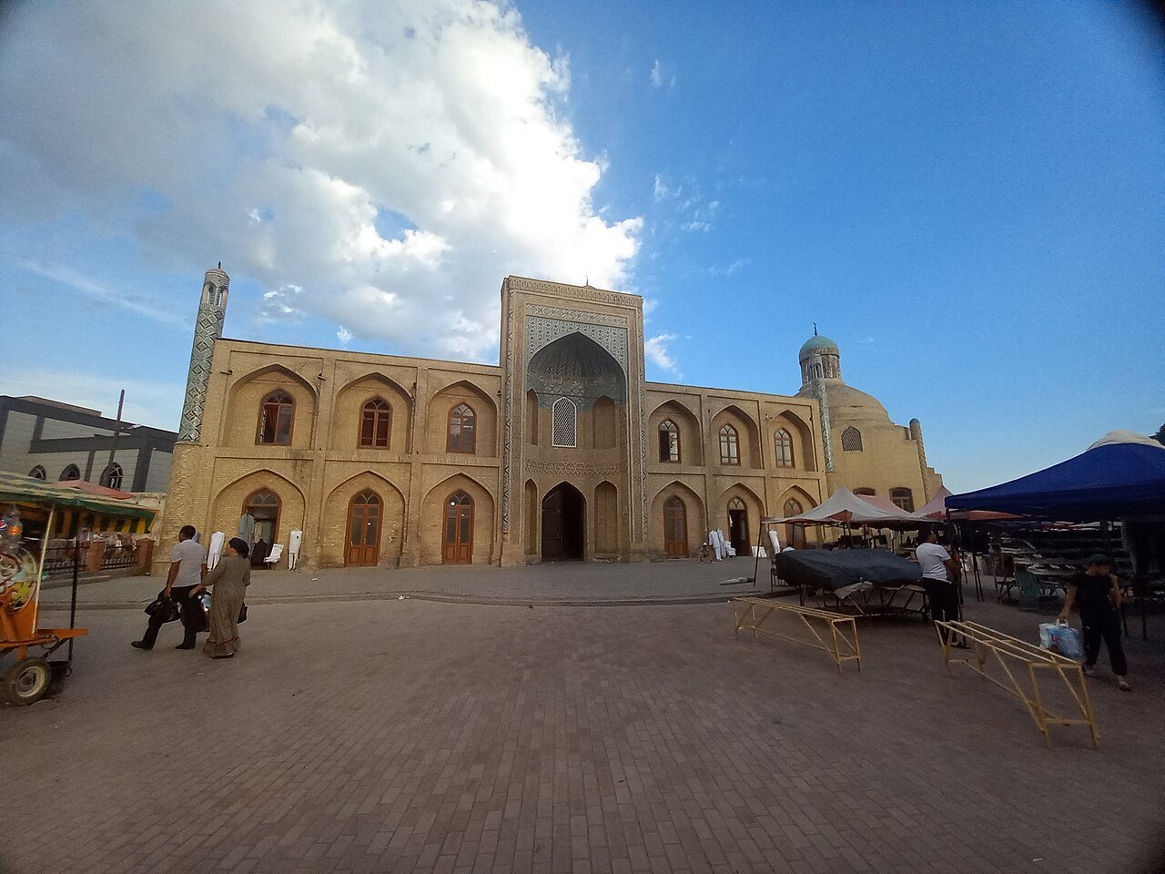
- 1910–1912: the Mulla Kyrgyz Madrasa is built.
- Twentieth century onward: industrial growth and new districts expand the city.
The northern valley: understanding Namangan's setting
Namangan developed in the northern part of the Fergana Valley, where settlement depended on the relationship between cultivated land, water and routes. The valley is often described as naturally fertile, but that description leaves out the labour needed to make it productive. Channels had to be maintained, water distributed and fields connected with markets. The city grew within this managed landscape rather than standing apart from it as a purely commercial or administrative centre.
Its position also connected several different environments. Agricultural settlements, foothill communities and larger towns exchanged goods and people. A market could bring together produce from nearby fields, objects from urban workshops and materials obtained through longer journeys. This mixture of local and regional exchange is more useful for understanding Namangan than an image of a single caravan road passing through an otherwise empty landscape.
The distinction between city and region is essential. Namangan Region includes places with their own long histories, including Aksikent and Chust. Their archaeology, crafts and monuments help explain the wider setting, but they should not all be assigned to Namangan city. A careful itinerary identifies where each attraction is located and why its history is connected. The result is a clearer picture of the northern valley's changing network of settlements.
Salt, place-names and uncertain beginnings
The familiar explanation of Namangan's name derives it from Persian words associated with a salt mine. This tradition connects the place with a material resource and an earlier landscape of work. It is useful cultural information, but it does not provide a precise foundation date. A name can develop gradually, change in pronunciation or acquire an explanation long after the settlement itself began.
Local accounts often identify the seventeenth century as an important period in Namangan's emergence as a town. That need not mean there was no earlier settlement in the area. Urban status, the appearance of a name in a document and the beginning of human occupation are separate historical questions. Confusing them can turn a useful date into an exaggerated claim that an entire community suddenly appeared in one year.
For visitors, the distinction helps explain the cityscape. Many visible buildings are considerably later than the earliest settlement history. Houses and workshops constructed in earth, timber and brick could be repaired or replaced repeatedly. The age of a town therefore cannot be judged only by the oldest standing façade on a tourist route. Namangan's past also resides in its regional relationships, patterns of occupation and the memory carried by its communities.
Aksikent before Namangan's rise
Aksikent, also written Akhsikath or Ahsiket, was one of the major historic centres of the Fergana Valley. Its archaeological remains belong to a separate settlement near the Syr Darya. The site preserves evidence of fortification, urban organisation and production, including a notable metallurgical tradition. It provides a different kind of historical experience from Namangan's surviving religious buildings: the visitor encounters the structure of an excavated city rather than an intact monumental ensemble.
The relationship between citadel, town and outer production areas helps explain how an urban centre functioned. Defence, government, residence and craft were connected but not identical activities. A plan can make those distinctions visible where standing remains alone are difficult to interpret. Earthworks and excavated foundations require explanation, but they can reveal systems of urban life that a richly decorated portal does not show.
Aksikent also had more than one phase and location in its long history. Destruction and rebuilding altered the settlement over time. It is therefore misleading to attach every event associated with the name to the same visible mound without checking the period. The site's value lies partly in this complexity: it records the changing geography of a major valley centre and helps explain why another town could later gain importance nearby.
Earthquake, migration and a changing urban balance
Local histories connect Namangan's seventeenth-century growth with movement from Aksikent after a destructive earthquake, commonly dated to around 1620. The account should be understood as a major influence on urban development rather than a complete explanation for every aspect of Namangan's origins. Migration worked within an existing landscape of settlements, agricultural resources and routes.
People moving from a damaged city brought more than additional population. Craftspeople carried practical knowledge, merchants retained relationships, and religious families brought networks of learning and patronage. These resources could help a receiving town grow even when little physical material was transferred. Urban history is therefore also a history of mobile skills and social connections, not only the construction and destruction of buildings.
The comparison with Aksikent is especially rewarding because it challenges the idea of a permanent capital. A settlement can decline while its people and activities contribute to another centre. Namangan did not become Aksikent under a new name; it developed partly through the consequences of Aksikent's changing fortunes. Keeping the two places distinct allows the relationship between them to become more informative.
The Kokand Khanate and the role of a provincial city
During the eighteenth and nineteenth centuries, Namangan belonged to the political world of the Kokand Khanate. The court at Kokand depended on towns and agricultural districts throughout the valley for revenue, goods and support. Namangan's contribution included production, trade and the resources of its surrounding countryside. A provincial city was an active part of the state, even when royal chronicles concentrated on events at the capital.
Government could support economic activity through security and infrastructure, but taxation and conflict could also burden it. The effects varied among merchants, farmers, craftspeople and religious institutions. A statement that a city prospered under a ruler should therefore be examined more closely: which activities expanded, who benefited and what demands accompanied the change? These questions connect political history to the practical life of the town.
Namangan's built heritage reflects this wider society of patrons and users. Not every substantial foundation was a direct royal commission. Local wealth, religious authority and community needs shaped buildings at a scale suited to the town. This makes Namangan a useful counterpart to Kokand. The palace explains the presentation of kingship; a Namangan madrasa or memorial explains how institutions beyond the court occupied urban space.
Yangiaryk: why a canal belongs in a city chronicle
The Yangiaryk canal, dated to 1821 in the national tourism account, marks an important stage in Namangan's irrigation history. A canal can be less visually dramatic than a mausoleum, yet its consequences for a city may be more extensive. Water supports cultivation, which supplies food and materials, attracts population and generates revenue. New or improved distribution can alter the relationship between town and countryside over a wide area.
Construction was only the beginning. Channels required maintenance and arrangements for access, and their usefulness depended on the continuing availability and management of water. The history of irrigation therefore includes cooperation and potential conflict among users. A ruler might sponsor a project, but many people performed the labour that kept it functioning. Their contribution is part of the city's history even when their names are absent from inscriptions.
This perspective makes gardens and agricultural surroundings historically meaningful. They are not merely pleasant scenery outside the monuments. They reveal the productive landscape that sustained urban life. The connection between water, settlement and craft also explains why changes beyond the city boundary could influence markets and neighbourhoods within it. Namangan's growth was a regional process with an urban centre.
Workshops, markets and the craft economy
Namangan has long been associated with skilled production, including textiles, metalwork and pottery. A craft town depends on more than individual talent. Makers need materials, tools, customers and ways of teaching their work to others. Workshops connect these requirements, while markets provide information about demand and quality. The result is an economy built on accumulated knowledge as well as physical goods.
The division of labour can extend across households and towns. One person prepares a material, another shapes or decorates it, and a merchant brings it to a customer. A finished object conceals this cooperation. Looking at how it was made restores some of the social history behind it. The question is not only whether an object is attractive, but which skills and relationships made its production possible.
Chust, within the wider region, has a distinctive reputation for knives and skullcaps. That identity should be respected rather than absorbed into a general label of Namangan craft. Regional connections do not erase local specialisation. A visit to both places can show how different towns develop recognisable reputations while participating in shared markets and cultural traditions.
Neighbourhoods and the scale of everyday architecture
Namangan's older urban fabric is not defined solely by large monuments. Streets, courtyards, shops and small religious buildings form the setting in which most residents experienced the city. Their arrangement reflects practical needs: privacy, shade, access to water, proximity to work and relationships between neighbours. An urban history focused only on prominent patrons leaves much of this lived environment unexplained.
Courtyard buildings create a transition between public streets and more protected interior space. A plain exterior can conceal carefully arranged rooms and a shaded veranda. This difference is not evidence that decoration was unimportant; it shows that architectural display could be directed towards particular users and occasions. Hospitality, family life and work each imposed different requirements on a house.
These neighbourhoods are living places. Their residents are not obliged to make private interiors available as heritage attractions. The most useful observation often comes from public streets and designated sites, with permission sought for closer access. Respecting present use makes the history more accurate: the city is not a preserved stage set, but a place whose inherited forms continue to be adapted to contemporary needs.
Khoja Amin: memory in brick and inscription
The Khoja Amin memorial is one of Namangan's principal historic sites. The mausoleum's façade and dome are associated with the later eighteenth century, while the ensemble developed through subsequent additions and repairs. Local tradition connects the person commemorated with a religious lineage associated with Tashkent. That genealogy belongs to the site's remembered history and should be distinguished from what its surviving architectural fabric can establish directly.
The building rewards close attention to the treatment of its portal and inscriptions. Brick and carved or moulded surfaces create depth through light and shadow, while written passages add a textual layer to the architecture. An inscription is not simply ornament that happens to resemble writing. It may express religious devotion, identify a patron or preserve information relevant to the building's history.
The present ensemble is incomplete compared with its earlier form. Surviving parts therefore need to be read alongside information about loss and repair. A visitor should not assume that the current arrangement represents one untouched construction campaign. The monument's historical value includes the sequence of care, alteration and survival through which it reached the present.
Mulla Kyrgyz Madrasa and a remarkable late date
Mulla Kyrgyz Madrasa was built in 1910–1912, according to the Namangan administration's heritage account. The date is especially revealing: the building belongs to the period of Russian imperial rule, decades after the end of the Kokand Khanate. Traditional religious architecture continued to be commissioned within a changed political framework. The transition to colonial administration did not instantly end local patronage or the demand for religious education.
Its plan responds to an existing urban site rather than reproducing a perfectly symmetrical ideal. That adaptation is one of the building's most interesting features. Architecture in a working town must negotiate boundaries, available land and neighbouring structures. An irregular plan can therefore provide evidence of urban circumstances, not simply a failure to achieve the grand geometry of a larger madrasa elsewhere.
The entrance receives particular decorative attention, establishing the institution's public identity. Inside, the organisation of courtyard and rooms points towards its educational purpose. The difference between outward display and inward use is worth noticing. A madrasa needed to be recognisable in the town, but it also had to accommodate the everyday activities of teachers and students.
The site has also been considered for contemporary craft and tourism uses. Such proposals belong to a later chapter in its history and should not be confused with its original function. Whatever the current arrangement, the central historical question remains how a building designed for one institution can be cared for and used meaningfully as the city around it changes.
Epigraphy: reading the city through its buildings
Research published in the Architectural Epigraphy of Uzbekistan series has examined inscriptions on Namangan's monuments. The work has helped clarify names of patrons and craftsmen, dates and repairs. It has also identified errors introduced into some texts during restoration. This makes the city's heritage a useful example of why the careful reading of surfaces matters to historical knowledge.
A date in an inscription needs interpretation. It may refer to construction, a death, a repair or the writing of the text itself. Chronograms can encode a date through the numerical values of letters, requiring specialist reading. A visitor does not need to perform that analysis personally, but understanding that it exists helps explain why a scholarly catalogue may offer a more precise history than an abbreviated tourism description.
The study of inscriptions also restores some visibility to people beyond rulers. A craftsman's signature or a patron's name can connect a building to an individual life. Conservation must preserve that information as well as the overall visual effect. Replacing a worn surface with a clean but inaccurate text can make a monument look complete while weakening its value as a historical document.
Imperial rule, Soviet change and urban expansion
The annexation of the Kokand Khanate in 1876 placed Namangan within the Russian Empire. Administration, commercial connections and the regional economy changed, while established communities continued to use and reshape the town. The construction of Mulla Kyrgyz Madrasa shows that the period cannot be described solely through new imperial buildings. Older forms of patronage and learning remained active within altered conditions.
Soviet rule brought further changes to production, property, education and religious institutions. Industrial and residential development expanded the city beyond its earlier neighbourhoods. Historic buildings could acquire new uses or lose the financial and institutional support that had maintained them. Their survival depended on a combination of adaptation, conservation and the choices made by successive authorities and communities.
The resulting city contained several historical layers at once. A resident could live in an older neighbourhood, work in a modern enterprise and encounter a former religious building used for a new purpose. Continuity and disruption were not mutually exclusive. Understanding those combinations produces a fuller history than dividing the twentieth century into a simple story of either complete loss or uninterrupted tradition.
Flowers, public space and independent Uzbekistan
Since independence in 1991, Namangan's religious and architectural heritage has acquired renewed public visibility. At the same time, the city's contemporary identity includes manufacturing, expanding residential districts, parks and a strong association with flowers. These are parts of modern urban life rather than surviving features of a seventeenth-century town. They deserve to be understood in their own historical context.
Flower displays and public gardens connect civic identity with the experience of shared space. Their appearance depends on planning, maintenance and seasonal work. The city's reputation for greenery therefore has a practical foundation, just as its older agricultural prosperity depended on water management. A pleasant landscape is also an environment produced and cared for by people.
Modern leisure complexes such as Afsonalar Vodiysi should be distinguished from historic monuments. They may contribute to a visitor's experience, but their architecture is not evidence of the khanate or medieval valley. Making the distinction allows both kinds of place to be appreciated honestly: one offers contemporary recreation, the other helps explain earlier institutions and urban life.
Bringing the layers together on a visit
Start with Mulla Kyrgyz Madrasa to understand late local patronage, then compare it with the older Khoja Amin memorial. Look for differences in plan, materials and purpose. Add time in the surrounding public streets and markets to place the buildings within a functioning city. The relationship between monument and neighbourhood is one of Namangan's most informative features.
Treat Aksikent as a separate excursion. A site plan or informed guide can help explain its fortifications and archaeological remains, while the comparison with Namangan reveals the movement of urban importance over time. If extending the journey to Chust, keep its craft identity distinct. These connections create a regional history without collapsing every place into the name of the present provincial capital.
Namangan's strongest historical experience comes from close observation. A canal date, an adapted courtyard, a repaired inscription and a workshop technique may each reveal more than an oversized claim about antiquity. Together they tell the story of a city shaped by water, migration, patronage and work, whose past remains connected to the everyday life of the northern Fergana Valley.
Reading the history on a visit
Begin with Mulla Kyrgyz Madrasa and a historic memorial, then explore the surrounding commercial streets. For an archaeological contrast, make a separate excursion to Aksikent. Ask local guides to distinguish documented dates, later restoration and stories passed down through tradition.
Read Namangan alongside Kokand to understand political connections, and alongside Margilan to compare different expressions of the valley’s craft culture.
Sources and further reading
- Uzbekistan Tourism: Namangan
- Namangan administration: Mulla Kyrgyz Madrasa
- Meros heritage catalogue: Mulla Kyrgyz Madrasa
- Cultural Legacy: Architectural Epigraphy of Uzbekistan — Namangan
Namangan’s early chronology is less precise than the dated inscriptions of its later monuments. The distinction is retained here rather than replaced by a single legendary foundation date.