

← All historic cities of Uzbekistan
Uzbekistan • City chronicles
The History of Shakhrisabz
Shakhrisabz is closely associated with Amir Timur, but its history begins long before his empire. The city occupies the historic Kesh oasis, south of the mountain routes from Samarkand. Its surviving monuments express an unusually personal side of Timurid rule: the ruler’s homeland, family memory and ambitions written in architecture.
The name Shakhrisabz means “green city”. That image belongs to an irrigated oasis, where gardens, fields, markets and settlements supported one another. The great ruins of Ak-Saray make a powerful first impression, but the city’s history also includes scholars, local rulers, ordinary neighbourhoods and difficult modern conservation choices.
At a glance: Shakhrisabz through time
- Antiquity and the early Middle Ages: the Kesh oasis develops within the wider world of Sogdiana.
- Eighth century onward: the region becomes part of Islamic Central Asia.
- 1336: Timur is born in the Kesh region.
- Late fourteenth century: major Timurid building projects transform the city.
- Fifteenth century: Timur’s successors continue religious and dynastic patronage.
- Early modern period: Shakhrisabz retains a distinctive position within the politics of the Bukhara region.
- 2000: its historic centre enters the UNESCO World Heritage List.
- 2016: UNESCO places the property on the List of World Heritage in Danger.
Kesh and the green city: two names, one changing landscape
The names Kesh and Shakhrisabz belong to different but overlapping parts of the city’s history. Kesh appears in accounts of the ancient and medieval oasis, while Shakhrisabz, meaning green city, became increasingly associated with the town transformed by Timurid patronage. The older name did not disappear everywhere at once. Writers continued to use different forms according to language, period and the traditions on which they relied. A change of name should not be mistaken for the sudden creation of a completely new settlement.
The historical geography is also more complex than the modern municipal boundary suggests. The Kesh oasis included a network of settlements in the upper Kashkadarya region, with the area around present-day Kitab playing an important role in discussions of earlier urban development. The principal focus of settlement and authority could shift over time. It is therefore useful to distinguish the wider oasis from the exact location of a surviving monument in today’s Shakhrisabz.
The name green city draws attention to the environmental basis of that development. Fields, orchards and gardens depended on water reaching the cultivated land from the surrounding mountain systems. The greenery was an achievement maintained through labour and water management. It supplied the food, materials and revenue on which urban institutions depended. A city celebrated for an imperial palace was also a place sustained by farming and ordinary exchange.
Modern spellings include Shahrisabz, Shakhrisabz, Shahr-i Sabz and the form Shakhrisyabz used by UNESCO. These do not identify different places. They reflect transliteration through different languages and conventions. Knowing this helps when comparing a map, a museum label and a scholarly source. The variation is part of the city’s international documentary history rather than evidence of uncertainty about which modern town is being discussed.
The upper Kashkadarya and routes across the mountains
Shakhrisabz occupies a position south of the mountain routes from Samarkand. That setting shaped its economic and political importance long before Timur. Passages through the ranges connected the upper Kashkadarya with other parts of Sogdiana and with routes leading further south. Movement through this landscape depended on season, weather, transport and the security of the roads. A mountain route was an opportunity for connection, but it could also create a barrier.
The relationship with Samarkand was therefore close without making the two places identical. They occupied different local environments and served different combinations of regional needs. Control of routes between them could matter to rulers, merchants and military forces. The contrast also helps explain why the same imperial dynasty could invest in both cities for different reasons. A principal capital and an ancestral homeland did not have to perform the same political function.
The surrounding agricultural landscape supported a settled population through irrigation and cultivation. Water channels, village organisation and the maintenance of fields were central to the region’s prosperity. A ruler’s ability to build on a monumental scale depended partly on the availability of those resources and on the capacity to draw in labour and materials from further away. The palace and the oasis belong to the same economic history.
For travellers approaching from Samarkand, the route itself can become part of the historical experience. The transition between mountain passages and cultivated land explains more than a simple distance on a map. It suggests why movement, defence and provisioning mattered. The modern road is not a direct survival of every older route, but the underlying geography remains a useful guide to the choices available to earlier communities.
Kesh within the world of Sogdiana
Before its association with Timur, Kesh belonged to the southern part of the Sogdian cultural and political world. Sogdiana was not a single unchanging state with one administrative structure throughout antiquity. Its oasis centres could have local rulers, distinctive interests and changing relationships with larger powers. Kesh participated in this world through agriculture, trade and political connections rather than as a minor settlement awaiting a famous future.
The history of the region extends through several imperial and local contexts. Archaeological evidence and written accounts illuminate different periods, but they do not always map neatly onto the streets of the modern town. Early settlement should therefore be discussed at the appropriate scale. Evidence from the wider oasis cannot automatically be assigned to the exact site of Ak-Saray or another later monument.
The ancient and early medieval economy combined local production with wider exchange. Farmers supplied towns; craftspeople made tools and goods; routes allowed products and information to move between regions. The influence of distant political powers did not erase these practical relationships. A change of ruler could alter taxation or security while leaving much of the everyday work of the oasis in the hands of the same communities.
This earlier history is important because it corrects a common imbalance in visitor narratives. Shakhrisabz is often introduced only as Timur’s birthplace, as though nothing significant existed before the fourteenth century. The ruler’s attachment to the region was possible because it already had a developed social and economic landscape. His construction programme transformed an established place; it did not create urban life from nothing.
Islam, scholarship and the medieval oasis
Arab expansion brought Kesh into the changing political world of Islamic Central Asia during the eighth century. Military control, religious conversion and the development of institutions were separate processes that unfolded over time. The city’s later Islamic identity should not be projected unchanged onto the first encounter with Arab armies. Local languages, customs and relationships continued to develop within the new framework.
The region subsequently participated in the networks of learning and commerce linking Central Asian cities. Teachers, students and religious figures could travel between places, while books and scholarly reputations circulated further still. A town’s intellectual life depended on access to teachers and resources as well as on the patronage of rulers. Smaller centres could contribute to those networks without becoming permanent imperial capitals.
Religious institutions also shaped urban space. Mosques, places of study and shrines attracted activity and could encourage the growth of surrounding neighbourhoods. Their support required income, maintenance and relationships with the wider society. The institution was more than the building in which it operated. A structure might be rebuilt while the memory or function associated with the place continued.
The later Timurid memorial complexes grew within this broader history of religious authority and local attachment. Their significance cannot be explained only by the ruler’s desire to build impressive monuments. They connected the dynasty with respected figures and established sacred places. The resulting architecture expressed relationships between family, spiritual prestige and government that had roots in the region’s earlier Islamic centuries.
The Mongol inheritance and the world into which Timur was born
The Mongol conquests transformed political authority across Central Asia in the thirteenth century. Kesh belonged to the wider region affected by the collapse of earlier states and the establishment of new ruling arrangements. The subsequent Chaghatayid world was not static. Authority shifted among khans, military leaders and local groups, creating a political environment in which formal titles and effective power did not always coincide.
Timur emerged from that environment. His rise cannot be explained simply as the appearance of an exceptional individual outside history. He operated through alliances, military followers, family relationships and existing ideas of legitimacy. The political culture of the post-Mongol region shaped what he could claim and how he presented himself. Understanding those constraints makes his later achievements and choices more intelligible.
The Barlas group with which Timur was associated belonged to this Central Asian world of overlapping steppe and settled traditions. Language, social organisation and political identity had developed through long interaction. Modern national categories cannot be transferred directly onto every aspect of the fourteenth century. A historically careful account can recognise Timur’s importance in Uzbekistan’s heritage while describing the different political and cultural terms of his own time.
Kesh’s role in this story was both practical and personal. It provided a regional setting in which relationships and loyalties developed. Later, the memory of origins became a resource that Timur could express through patronage. The homeland was not merely a sentimental subject. It was part of how an expanding ruler connected his authority to a recognisable place and community.
Timur’s birth, family and attachment to Kesh
Timur was born in the Kesh region in 1336. Accounts often identify a settlement near the town rather than a location within the boundaries of the modern city. That distinction matters when a visitor encounters the phrase birthplace of Timur. The phrase expresses a strong regional association, but it should not be used to imply that a particular surviving palace marks the exact house or room in which he was born.
Family relationships connected Timur with the local social world before he became an imperial ruler. The later commemoration of relatives and spiritual figures in Shakhrisabz shows how those relationships remained important. A dynasty established through conquest still needed ways to represent continuity, ancestry and belonging. Architecture offered a durable and publicly visible means of doing so.
After consolidating his authority in 1370, Timur made Samarkand his principal capital. His continuing investment in Kesh demonstrates that political importance was not confined to one city. Samarkand organised the imperial centre and received the resources of a vast realm, while Shakhrisabz became a major setting for the presentation of origins and dynastic memory. The two cities were complementary parts of the same political project.
For travellers, comparing them is more informative than deciding which was Timur’s real city. Samarkand reveals the ambition of a metropolitan capital; Shakhrisabz gives greater prominence to the ruler’s regional attachment and family commemorations. Both were transformed by imperial power, including the ability to command labour and materials. Their differences help explain the several ways in which a ruler could use urban patronage.
Empire, artisans and the resources behind the monuments
Timur’s campaigns brought wealth, captives and skilled workers into the regions he favoured. The movement of artisans after conquest is an essential part of the history of Timurid architecture. It helped concentrate techniques and experience from different places, but it was frequently coercive. The beauty of a monument should not erase the circumstances in which some of the people who built it were brought to the site.
Ak-Saray’s construction drew on that imperial capacity. Craftsmen from Khorezm were among those associated with the project, linking the palace with a region known for skilled building and decoration. The transfer of people meant more than the movement of individual hands. Workers brought methods, habits of design and practical knowledge developed in other workshops. Collaboration could produce new combinations while also involving unequal relations between patrons and labourers.
A major palace required a complex supply system. Bricks, timber, stone, pigments and other materials had to reach the site in usable quantities. Food and accommodation were needed for workers, while specialists coordinated structure and ornament. The surviving entrance is the visible result of that larger organisation. Its scale communicates the ruler’s ability to mobilise resources, not simply an architect’s preference for large dimensions.
The names of patrons survive more readily than those of most workers. That imbalance affects the way monuments are narrated today. Looking closely at a pattern, joint or carved detail can help restore attention to skill and labour. It does not identify every anonymous maker, but it makes the collective nature of the achievement visible. Timurid architecture was commissioned by powerful individuals and realised through the work of many people.
Ak-Saray: beginning an imperial palace in 1380
Construction of Ak-Saray began in 1380, after Timur’s campaigns had greatly increased the resources available to him. The palace’s name is generally translated as White Palace, although the surviving decoration makes clear that its appearance was not simply that of an unadorned white building. Names of royal structures can carry symbolic associations as well as literal descriptions of a dominant surface colour.
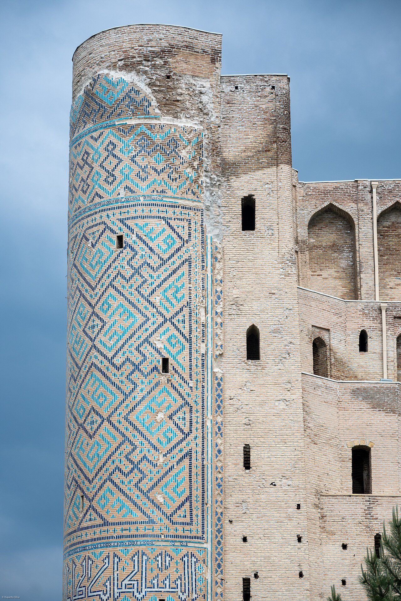
The palace was a much larger complex than the remains now visible. Its entrance formed part of an approach to spaces of royal residence and ceremony. The surviving towers or pylons establish an extraordinary scale, but they do not preserve the entire sequence of courts, halls and service areas. Reconstructing that sequence requires archaeological evidence and historical accounts. A visitor is looking at a powerful fragment rather than a complete palace with a missing roof.
Monumental entrances performed a political function. They controlled the transition from the surrounding city into a space associated with the ruler. Their height and decoration established expectations before a visitor reached an audience or an interior court. Architecture created an experience of approaching authority. In an imperial setting, that experience could be as important as the practical need for an opening in a wall.
The date 1380 marks the beginning of a long building process rather than a single moment of completion. Large projects required successive stages, and decoration could continue after parts of a complex became usable. Historical accounts of an unfinished or still-decorated area do not necessarily contradict evidence that the palace was already functioning. Construction and occupation could overlap, especially where the ruler’s ambitions continued to expand.
What the surviving portal reveals
The remains of Ak-Saray can be read at several scales. From a distance, the entrance communicates mass and height. Nearer the masonry, surviving areas of ornament reveal patterns, inscriptions and the division of the surface into carefully organised fields. The effect depends on geometry and proportion as well as on colour. Decorative richness was controlled by the architectural framework rather than applied without structure.
Glazed surfaces and patterned brickwork required precise preparation. Individual units had to work within a larger design, and the design had to respond to the form of the building. A repeated motif seen high on the facade was produced through many small acts of skilled labour. This relationship between a distant visual effect and close workmanship is one of the most rewarding aspects of Timurid architecture.
Inscriptions belong to the same programme of representation. They could express religious ideas, identify patronage or communicate claims about power and magnificence. Popular versions of famous sayings associated with Ak-Saray vary in wording. Unless a translation is tied to a specific inscription and reliable study, it is better to describe the message than to present a dramatic quotation as exact. The monument’s political ambition is visible even without an embellished slogan.
The missing arch and vanished parts of the complex also deserve attention. Absence is part of the evidence. It affects how the surviving entrance stands and how conservators must protect it. Imagining the lost structure can help explain the scale, but an illustration or verbal reconstruction should remain clearly distinguished from the actual remains. The ruin’s power comes partly from the tension between what can still be seen and what must be reconstructed through research.
Clavijo’s visit and the palace seen by an outsider
The Castilian embassy led by Ruy González de Clavijo travelled to Timur’s court in the early fifteenth century. Its account is one of the important outside descriptions of the imperial world, including the splendour associated with Shakhrisabz and Samarkand. The journey connected Central Asia with a diplomatic environment extending far beyond the immediate region. Timur’s court was not isolated from the interests of rulers to the west.
An envoy observed a palace for particular reasons. The scale of a building, the treatment of visitors and the organisation of ceremony could all indicate the wealth and authority of the ruler being approached. Descriptions of magnificence were therefore part of a diplomatic assessment as well as an expression of personal astonishment. The account is valuable because it records impressions from a contemporary visitor, but it is not a neutral architectural survey.
Clavijo’s narrative helps modern readers imagine a palace more complete and actively used than the fragment visible today. It can be compared with surviving fabric and archaeological interpretation. Where the evidence does not align neatly, the disagreement should prompt questions rather than an invented certainty. A traveller might misunderstand a function, a later copy might alter a detail, or the building itself might have changed during its long construction.
The account also restores movement to a site now often experienced as a static ruin. Envoys travelled, waited, entered, observed and continued their journey. The palace belonged to routes and ceremonies rather than existing only as an object to admire. Thinking about those movements helps visitors understand Ak-Saray as a working setting of power within an empire, not merely as a very large decorated gateway.
Dorus Saodat and the commemoration of a dynasty
The Dorus Saodat complex is closely connected with Timur’s family and the memory of his son Jahangir. Dynastic burial was an important part of the construction of political identity. A ruling family could establish a place where ancestry, mourning and public authority came together. The resulting institution served religious and social functions as well as preserving tombs.
The complex once included more than the remains that survive today. Prayer spaces and facilities associated with a religious community and pilgrims formed part of a broader setting. A mausoleum was not necessarily an isolated building visited only on rare ceremonial occasions. Its maintenance and use could involve people whose work sustained the site across generations. The institution’s life extended beyond the burial event that first gave it prominence.
Jahangir’s death was a personal loss within the ruling family, but its architectural commemoration also had a public dimension. The monument presented the dynasty’s continuity and status. Grief and political representation were not mutually exclusive. Royal families used durable buildings to preserve memory in a form that could be encountered by later rulers, religious communities and visitors.
The surviving structures should be distinguished from the original extent of the complex. Damage, rebuilding and changes in the surrounding town have altered the relationships between its parts. Historical plans and archaeological evidence are necessary to understand what has disappeared. The modern visitor can still recognise the connection between family memory and sacred space, provided the fragmentary state is explained rather than concealed by an account of a supposedly intact Timurid ensemble.
The crypt associated with Timur and the burial in Samarkand
The underground burial chamber associated with Timur is among the sites most likely to produce confusion in a brief tour. Its connection with the ruler belongs to the history of a planned or intended dynastic burial arrangement in Shakhrisabz. Timur’s actual burial is at Gur-e Amir in Samarkand. The existence of a structure associated with his intended resting place does not mean that two cities contain his original grave.
The difference is historically revealing. Rulers could plan the location and form of their commemoration, but events did not always follow those plans. Timur died in 1405 during preparations for a campaign, and the circumstances of his death and the political situation shaped what happened afterwards. A monument conceived during a ruler’s life could acquire a different meaning when the intended use did not occur.
The chamber should be examined through its material and spatial qualities as well as through the story attached to it. Stonework, inscriptions and the arrangement of the interior belong to a particular architectural conception of burial. An underground space produces a different experience from a tall mausoleum rising above the city. Its relationship with the larger complex is essential to understanding why it was built where it was.
For visitors, the distinction between intended function and actual use offers a broader lesson. Historical buildings do not always fulfil their original programme. Political change, death, financial limits or practical circumstances can intervene. The resulting structure remains important evidence, but its story must include the interruption. Explaining that interruption is more informative than presenting a simple label that incorrectly identifies the site as Timur’s actual tomb.
Dorut Tilovat and the authority of a spiritual teacher
Dorut Tilovat is associated with the memory of Shamsiddin Kulal, a revered religious figure connected with Timur’s family. The site demonstrates another route through which a dynasty could establish legitimacy. Honour paid to a respected spiritual teacher linked political power with a source of authority that was not derived solely from military success or royal descent.
The ensemble developed through successive patronage rather than appearing in its present form at one moment. Burial, worship and remembrance were connected within a space whose buildings had different dates and purposes. The relationship between them matters as much as the appearance of any one facade. A sacred precinct can preserve continuity of meaning while its physical form is repeatedly enlarged or renewed.
The association with Timur’s father and family places the complex within a local history of kinship and spiritual attachment. These relationships should not be flattened into a generic statement that a ruler built religious monuments because he was pious. Patronage could express personal devotion, family memory and public claims about rightful authority at the same time. Those meanings were not necessarily contradictory to the people who used the site.
For a modern visitor, the quieter scale of the ensemble provides an important contrast with Ak-Saray. The palace announces the capacity of an empire; the memorial setting brings attention to particular people and relationships. Both belong to the same political world, but they communicate through different architectural experiences. Comparing them prevents the city’s history from becoming only a catalogue of monumental dimensions.
Kok Gumbaz and Ulugh Beg’s continuing patronage
The Kok Gumbaz Mosque, generally dated to 1435, belongs to the continuation of Timurid patronage under Ulugh Beg. Its blue dome has become one of Shakhrisabz’s defining visual features. The building demonstrates that the city’s architectural history did not stop at Timur’s death. Later members of the dynasty continued to invest in places associated with family, faith and regional authority.
Ulugh Beg is widely remembered for astronomy and the observatory in Samarkand, but he was also a ruler whose patronage included educational and religious buildings. The mosque in Shakhrisabz should be understood within that wider role. An interest in mathematical astronomy did not separate a fifteenth-century prince from the political and religious responsibilities of government. His architectural activity operated across several cities and types of institution.
The mosque’s effect depends on the relationship between the dome, entrance and spaces used for worship. The colour of the dome is the most immediately recognisable feature, but the structure also organises movement and gathering. A building intended for collective prayer needed to work at the scale of a community. Its ceremonial appearance and practical function were connected.
Restoration has affected how the mosque is seen today. Renewed surfaces and the condition of the surrounding space belong to the monument’s later life. The date of the foundation does not imply that every visible tile is from the fifteenth century. A careful visit considers both the historical design and the work that has enabled it to survive. That distinction adds to the building’s story rather than reducing its importance.
Gumbazi Sayidon and the layered memorial ensemble
Gumbazi Sayidon, commonly associated with the later 1430s, adds another element to the Dorut Tilovat ensemble. Its name refers to the dome of the sayyids, a term connected with claims of descent from the Prophet Muhammad. Such descent carried religious and social significance in Central Asian societies. A burial association of this kind belongs to the relationship between genealogy, status and sacred memory.
The building’s place within the ensemble matters. Memorial structures could accumulate around a revered site, creating a concentration of tombs and places of worship. Their proximity expressed relationships between the people commemorated and the authority of the original sacred place. The resulting precinct was not simply a convenient area for several unrelated monuments.
The architecture also illustrates the difference between an individual commission and the long life of a burial complex. A structure could be built for one purpose and receive later associations or uses. Inscriptions and documented burials help establish those changes, while popular accounts sometimes compress them into one simple story. Where details differ between sources, a measured description is preferable to presenting every tradition as established fact.
Visitors can use the ensemble to practise reading chronology spatially. Compare the dates, functions and forms of neighbouring buildings instead of assuming that the visual unity indicates one construction campaign. The shared setting emerged through time. Its value lies partly in that accumulation, which connects different generations of Timurid patronage and later religious life within a relatively small area.
A city of mosques, markets, baths and houses
Shakhrisabz’s monumental remains once belonged to a more closely connected urban environment. Houses, streets, commercial buildings and everyday institutions occupied the spaces between the royal and religious landmarks. These ordinary structures were not incidental to the city’s historical character. They helped explain how people approached, used and maintained the major monuments.
Markets connected the urban population with farmers, travelling merchants and local craftspeople. Baths served practical and social needs. Neighbourhood mosques and water points created repeated places of encounter. A functioning town required this range of institutions, and their importance was not limited to the period of the most celebrated ruler. They sustained urban life during years when no enormous palace was being built.
Domestic architecture organised privacy, household work and adaptation to the climate. Courtyards and inward-facing rooms created a different scale from the large public facades. The relationship between the two was part of the town’s spatial character. A monument rising above smaller buildings communicated its prominence differently from the same monument isolated in a broad open landscape.
This distinction has become central to modern debates about Shakhrisabz. Protecting a city is not the same as preserving only its largest buildings. The streets and houses that connect them can carry evidence of social organisation and everyday history. Once removed, that evidence cannot be fully replaced by new paving, lawns or a reconstruction of a facade. The ordinary fabric is part of what makes a monument historically intelligible.
Chorsu and the persistence of commerce
The Chorsu commercial building is a reminder that Shakhrisabz’s history continued beyond the peak of Timurid imperial investment. The name is associated with a crossroads, a practical location for exchange. A covered market structure concentrated activity where routes met, bringing together movement, trade and the need for protection from weather. Its function was embedded in the organisation of the town.
Commercial architecture responds to repeated practical problems. Goods need display and storage; customers need access; traders benefit from passing traffic; and a crowded crossing requires enough space for movement. Domed and vaulted forms can provide cover while admitting light and connecting several approaches. Such buildings are therefore works of urban organisation as well as examples of masonry technique.
The products and customers associated with a market change over time. A building may survive while the balance between local trade and tourism is transformed. Its current activity should not be treated as an exact reenactment of the past. The historical continuity lies partly in adaptation: a useful commercial place can remain important because successive generations find new ways to use it.
For visitors, Chorsu provides a different kind of evidence from Ak-Saray. It points towards the routines that kept the city functioning after royal priorities shifted. Buying, selling, repairing and supplying households did not end when the Timurid dynasty lost power. The market helps restore those centuries to a narrative that might otherwise jump directly from Timur to modern conservation.
After the Timurids: local power and the Bukhara connection
The end of Timurid rule in Transoxiana brought Shakhrisabz into the changing political world of the Uzbek dynasties. Its relationship with states centred on Bukhara was important, but local rulers and elites could exercise considerable autonomy. The town’s history was shaped by negotiation and conflict between regional interests and attempts at wider political consolidation.
Local independence was not an abstract preference for separation. It involved control of revenue, military resources, appointments and access to land. A ruler in Bukhara might seek more reliable authority over the region, while local leaders had reasons to defend their own position. The surrounding geography and the strength of local relationships affected the outcome. A formal claim on a map did not always translate into consistent day-to-day control.
The city’s inhabitants experienced these struggles through taxation, security and the disruption or continuation of trade. Political chronicles often focus on the leaders, but the consequences extended to cultivators, merchants, craftspeople and households. A campaign could interrupt supplies or impose new obligations even when the major monuments remained standing. Urban history includes those changes in daily circumstances as well as transfers of rule.
Later accounts sometimes explain the loss of a monument through one ruler’s destructive act. Such stories need to be checked against the evidence for gradual decay, reuse of materials and successive episodes of damage. The decline of a palace complex can occur over a long period. A responsible narrative should not turn every missing structure into proof of one dramatic event simply because that makes an easier story to tell.
Shakhrisabz and Kitab in the nineteenth century
Shakhrisabz and neighbouring Kitab remained important in the politics of the upper Kashkadarya during the nineteenth century. Their rulers and local power structures had a distinctive relationship with the emirate of Bukhara. The region’s history therefore differs from a simple account of a provincial town continuously administered from the capital without resistance or negotiation.
The expansion of Russian power in Central Asia altered that relationship. After the defeat of Bukhara in 1868, the emirate continued under Russian predominance, while further military intervention affected local centres. Shakhrisabz and Kitab were brought under more effective control of the emir in the context of these changes. The outcome connected the region to an imperial system even though it was not administered in exactly the same way as directly annexed Samarkand.
This layered political arrangement is useful when comparing cities on a journey through Uzbekistan. Tashkent became the administrative centre of Russian Turkestan; Samarkand was directly incorporated into the imperial structure; Bukhara retained an emir under external predominance; and places such as Shakhrisabz experienced the consequences through their relationship with that emirate. A common regional turning point produced different local histories.
The nineteenth-century town also continued its commercial and religious life. Royal ruins coexisted with functioning neighbourhoods, markets and places of worship. The survival of those activities should not be overshadowed by the decline of imperial palace architecture. Shakhrisabz was an inhabited place making practical use of an inherited environment, not a deserted Timurid stage waiting for twentieth-century restoration.
Craftsmanship and the transmission of local knowledge
The buildings of Shakhrisabz preserve evidence of specialised skills, but craft history also extends into domestic and portable objects. Embroidery, woodwork, ceramics and other forms of production connected households and workshops with regional markets. The work of making and maintaining objects contributed to the city’s economy and cultural identity across periods when large royal commissions were absent.
Skills were transmitted through observation, practice and relationships between experienced makers and learners. A design was not simply copied as a fixed image; it had to be realised in a material with particular properties. Stitching, carving, glazing and masonry each required different forms of judgement. The finished object records decisions about technique, available resources and the expectations of a customer or patron.
Modern craft production can retain those forms of knowledge while adapting to new markets. A product made for visitors may differ from one intended for a local household, and a workshop may use tools unavailable to earlier generations. Such changes do not automatically make the work meaningless. They are part of the tradition’s economic and social history. The useful questions concern process, training and material rather than a simplistic division between completely unchanged tradition and modern imitation.
Visitors can contribute to a more informed understanding by asking makers about how an object is produced. A conversation about the time required, the source of materials or the organisation of a pattern often reveals more than a general claim of antiquity. The history of Shakhrisabz becomes more human when the skills visible on monumental facades are connected with the continuing work of people who make, repair and teach.
The Soviet period: institutions, research and preservation
The revolutionary changes of the early twentieth century ended the emirate and brought the region into the new political arrangements of Soviet Central Asia. Shakhrisabz subsequently developed within the Uzbek SSR. Property, education, religious life and local government were transformed. The consequences reached beyond public institutions into the organisation of work and the daily lives of households.
The monuments acquired new forms of official attention. Archaeological investigation, documentation and restoration helped establish their place in the history of Central Asian architecture. These activities could preserve important evidence and make it available to scholars and visitors. They also changed the way the sites were understood, often separating their artistic or historical value from earlier religious and dynastic functions.
Preservation was not a single completed action. Buildings required repeated examination and repair, and approaches to conservation changed over time. The condition of masonry, decorative surfaces and foundations raised different technical problems. A photograph from one decade may show a monument in a state quite different from another. Those differences belong to the history of conservation and should not be ignored when interpreting the current appearance.
The wider town continued to develop around the monuments. New schools, workplaces, roads and housing changed the relationship between historic structures and everyday urban life. The Soviet period therefore forms part of the city’s physical and social history, even where visitors are most interested in the Timurids. It shaped the institutions and interpretive frameworks through which the Timurid past is encountered today.
Independence and the renewed public image of Timur
After Uzbekistan became independent in 1991, Timur acquired renewed prominence in public commemoration and national historical identity. Shakhrisabz’s association with his origins gave the city a particularly visible role. Monuments, anniversaries, restoration programmes and cultural events helped present the town as a major place in the country’s historical narrative.
Commemoration is an interpretation of the past in the present. It selects figures, achievements and meanings for public attention. Timur’s architecture and state-building can be celebrated while his military campaigns and the coercive foundations of empire still require historical explanation. A mature account can hold both subjects together. Admiration for artistic achievement does not require the omission of the suffering connected with conquest.
The modern statue of Timur and the landscaped spaces around the historic monuments belong to this later chapter. They should not be confused with Timurid design. Their scale, materials and placement express contemporary choices about how the ruler and the city should be represented. Comparing the old structures with the new commemorative setting reveals the continuing work of constructing public memory.
Tourism has become one of the ways that memory is communicated internationally. Visitors often encounter a concise story of birthplace, palace and empire. A fuller history adds the earlier oasis, the later town and the lives of inhabitants between those major moments. Shakhrisabz’s importance is not diminished by moving beyond a single heroic biography. The city becomes more interesting when its entire historical development is allowed to remain visible.
World Heritage inscription in 2000
UNESCO inscribed the Historic Centre of Shakhrisyabz on the World Heritage List in 2000. The recognised value included the Timurid monuments and the evidence of the city’s historical development. The property was therefore more than a collection of individual structures. The relationship between buildings and the surrounding urban fabric formed part of the reason for recognising the place internationally.
World Heritage status does not mean that a city is frozen in time or that residents no longer need modern services. It creates a framework for protecting the characteristics that make the place significant while managing change. Infrastructure, housing, access and economic activity still require attention. The difficulty lies in meeting those needs without destroying the evidence through which the city’s historical character can be understood.
The distinction between a monument and its setting is central. A palace entrance that once rose above streets and houses communicates a different relationship to the town when placed in a broad landscaped area. The structure itself may remain, but part of the evidence for its historical role can be lost. Urban heritage includes scale, routes, enclosure and the transition between public and domestic spaces.
For visitors, the inscription provides a reason to look at those less spectacular features. It does not require a technical understanding of conservation policy to notice how a building meets the surrounding ground, how people approach it or what kinds of structures stand nearby. Such observations help explain why international assessments may focus on the townscape rather than only on the condition of a famous facade.
Why the historic centre entered the Danger List in 2016
In 2016, UNESCO placed the historic centre on the List of World Heritage in Danger after extensive redevelopment affected the urban fabric. The concern was not simply that some monuments needed repair. It involved the loss and transformation of the relationships between major structures, residential areas and the historic town. Broad new spaces and other interventions altered the setting through which the property’s significance had been understood.
The case illustrates a difficult distinction. A project can make an area cleaner, more open or easier to photograph while damaging historical evidence. Those visible improvements do not answer every conservation question. If houses, lanes and established relationships are removed, the resulting environment may no longer communicate how the city developed or how its monuments functioned within ordinary life.
UNESCO’s assessments also raised concerns about materials, reconstruction and the consequences of interventions for authenticity. Authenticity is not simply the appearance of oldness. It concerns whether the evidence for a place’s history remains credible in its materials, design, use and setting. Replacing an aged surface with something visually impressive may alter that evidence, especially when the work cannot easily be reversed.
The designation should not discourage a thoughtful visit. It makes careful interpretation more important. Visitors can appreciate the surviving monuments while understanding that the spaces around them have been substantially changed. The current landscaped centre is part of Shakhrisabz’s recent history, and the debate around it belongs to the story of the city. Heritage status can change, so current decisions should be checked through UNESCO’s official record rather than assumed from an old guidebook.
How to read the city’s surviving evidence
A historical visit to Shakhrisabz benefits from separating four things: surviving fabric, documented reconstruction, later repair and modern presentation. These categories can overlap within one building. An original wall may support renewed decoration, while a modern path changes the way the monument is approached. The purpose is not to dismiss everything that has been repaired. It is to understand what each part can reliably tell us.
Start with the scale of Ak-Saray, then move closer to examine the remaining patterns and inscriptions. Compare the imperial entrance with the memorial settings of Dorus Saodat and Dorut Tilovat. At Kok Gumbaz, consider how the mosque belongs to the generation after Timur. The sequence allows political ambition, family memory, spiritual authority and continuing dynastic patronage to be read as related but distinct subjects.
Allow attention to extend beyond the principal facades. Remaining older buildings, street alignments and the contrast with recent landscaping help explain the conservation history. Where access is permitted, museums and explanatory displays can add plans or objects that reconstruct vanished relationships. A guide who distinguishes evidence from tradition can be especially useful in a city where familiar stories are often compressed for short visits.
The result is a richer experience than a search for the largest ruin or the most photogenic dome. Shakhrisabz brings together the long history of an oasis, the ambitions of an empire and the modern challenge of preserving a living place. Its monuments are exceptional, but their full meaning emerges when they are connected with the people, institutions and landscapes around them.
Reading the history on a visit
Begin with Ak-Saray, then compare its royal scale with the religious and commemorative spaces of Dorut Tilovat and Dorus Saodat. At each stop, distinguish surviving fabric, restoration and modern landscaping. Ask how the buildings once related to homes, markets and streets.
For a fuller Timurid journey, read The History of Samarkand alongside this chronicle. The two cities illuminate different parts of the same imperial story.
Sources and further reading
- UNESCO: Historic Centre of Shakhrisyabz
- UNESCO: conservation decisions and reports
- UNESCO: 2019 monitoring report
- Encyclopaedia Iranica: Kokand Khanate — regional relations with Shahr-e Sabz
Kesh, Shahr-i Sabz, Shakhrisabz and UNESCO’s spelling Shakhrisyabz occur in different sources. Their use should be read in its historical and geographical context.